Google, working with the United States Geological Survey, NASA and TIME, have released time lapsed satellite maps of the Earth from each year from 1984 to 2012. You can search the site for time lapsed images of locations from around the globe.
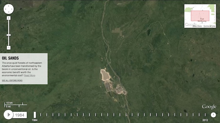
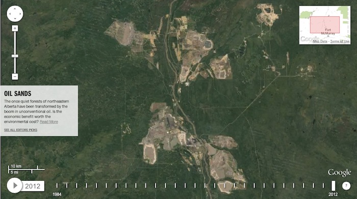
The population of the province of Alberta has grown by more than a million people in the past twenty-five years, which is demonstrate by the growth (and urban sprawl) in our cities over that period. Below are screenshots of four Alberta cities – Calgary, Edmonton, Red Deer, and Grande Prairie – from 1984 and 2012. Also included below are satellite images of oil sands operations north of Fort McMurray in 1984 and 2012. Visit the timelapse website to search for other images.
Calgary
![Satellite image of Calgary 1984 (from world.time.com/timelapse/)](https://daveberta.ca/wp-content/uploads/2013/05/Calgary-Alberta-1984.jpeg)
![Satellite image of Calgary 2012 (from world.time.com/timelapse/) Calgary Alberta 2012](https://daveberta.ca/wp-content/uploads/2013/05/Calgary-Alberta-2012.jpeg)
Edmonton
![Satellite image of Edmonton 1984 (from world.time.com/timelapse/) Edmonton Alberta 1984](https://daveberta.ca/wp-content/uploads/2013/05/Edmonton-Alberta-1984.jpeg)
![Satellite image of Edmonton 2012 (from world.time.com/timelapse/) Edmonton Alberta 2012](https://daveberta.ca/wp-content/uploads/2013/05/Edmonton-Alberta-2012.jpeg)
Grande Prairie
![Satellite image of Grande Prairie 1984 (from world.time.com/timelapse/) Grande Prairie Alberta 1984](https://daveberta.ca/wp-content/uploads/2013/05/Grande-Prairie-Alberta-1984.jpeg)
![Satellite image of Grande Prairie 2012 (from world.time.com/timelapse/) Grande Prairie Albera 2012](https://daveberta.ca/wp-content/uploads/2013/05/Grande-Prairie-Albera-2012.jpeg)
Red Deer
![Satellite image of Red Deer 1984 (from world.time.com/timelapse/) Red Deer Alberta 1984](https://daveberta.ca/wp-content/uploads/2013/05/Red-Deer-Alberta-1984.jpeg)
![Satellite image of Red Deer 2012 (from world.time.com/timelapse/) Red Deer Alberta 2012](https://daveberta.ca/wp-content/uploads/2013/05/Red-Deer-Alberta-2012.jpeg)
Oilsands operations north of Fort McMurray
![Oilsands operations north of Fort McMurray in 1984 (from world.time.com/timelapse/)](https://daveberta.ca/wp-content/uploads/2013/05/Alberta-Oilsands-1984.jpg)
![Oilsands operations north of Fort McMurray in 2012 (from world.time.com/timelapse/)](https://daveberta.ca/wp-content/uploads/2013/05/Alberta-Oilsands-2012.jpg)
5 replies on “Alberta cities grow: satellite images from 1984 to 2012.”
These look like tumours, growing out in all directions. But I’m sure our wondrous creations are nothing at all like that…
bigger cities means more jobs and people making more money, I think it is great, Alberta is awesome , everyone needs a home and we need to appreciate the people making Alberta hum.
Very cool. I wish I could fast forward to see what Edmonton will look like in 2040!
In the Grande Prairie case a significant portion of the growth is actually outside of the city limits. Go a little north to the lake just above the city and watch the growth of the “hamlet” of Clairmont.
In my 30 yrs on earth my hometown of red deer went from a small town to a big city. It’s crazy how much growth we have had here!!